There’s a large branch from a walnut tree hanging down from thirty feet high in the tree on Owl Acres. The other end is resting on the ground, bracing it from falling completely. It will take a professional tree service to finish disconnecting it from the tree and drop it to the ground. It is the worst of the damage from tree limbs downed by recent storms. Those storms brought hail, high winds, seven inches of rain, flooding, and tornadoes over the course of a few days. Violent weather is a factor of life on Owl Acres, especially this time of year. Although these storms spawned tornadoes, they all missed us—this time. Others weren’t so lucky. Each year some 1200 tornadoes occur in the United States. All states, even Alaska and Hawaii, get them once in a while. Iowa gets them every year with varying amounts of damage and loss of life.

This is a widowmaker. A limb broken high in a black walnut tree and still attached. Foliage and upper branches brace to the ground. The only safe way to deal with this is with a professional. Author photo
There are several sets of conditions that can cause tornadoes, most of which cause only weak ones that do minimal damage if any. The big ones, rated from 2 to 5 on the scale used to categorize them, are spawned in huge thunderstorms called supercells. To make a tornado of this magnitude, here’s what you need:
1. An unstable atmosphere, created when air masses come together that have different moisture, temperature, wind speed and wind direction components. For example, if you have warm moist air coming up from the south and cooler dryer air coming from the north, the two air masses collide. The warmer, moist air is more buoyant than the colder air, so it starts to rise in a column, gaining energy with altitude. This creates an updraft.
2. Wind shear. Wind shear occurs as two air masses with different wind speeds and direction move across each other. A 50-miles-per-hour difference in wind speed between the ground and about 18,000 feet is sufficient to start air spinning.
3. A spinning column of air. This starts out as a horizontal column like a pencil rolling across a table. It stands up to the vertical as it is pulled into the updraft, and continues to spin. Now our updraft is spinning on a vertical axis.
4. This creates a supercell thunderstorm with a mesocyclone spinning in the middle of it at an altitude of 10,000 to 20,000 feet. This mesocyclone may be miles wide and usually spins counterclockwise in the northern hemisphere. It can be detected by radar.
5. Next, you need Air spinning near the ground. To get that, you need a downdraft of cooler air from your mesocyclone. The downdraft spreads out ahead of the storm, If the updraft is strong enough, it will suck some of this colder downdraft air into the updraft. This starts another column of air, close to the ground, spinning.
6. Now let’s intensify the spinning near the ground. For this you need a strong updraft sucking air in and up, and the right temperature differences. The faster the updraft spins, the more air it pulls into its center. That makes it spin even faster.
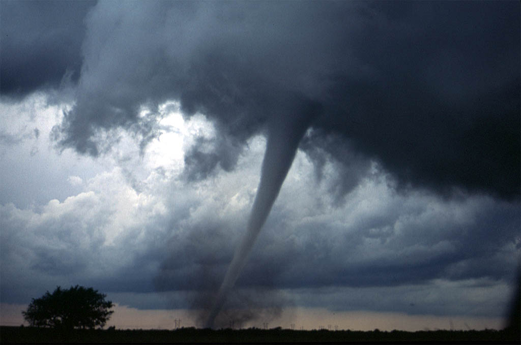
7. This spinning column of air, with wind speeds that can reach over 200 miles per hour, becomes a funnel cloud when it’s near the ground. When it touches the ground, it’s a tornado. If my description seems a bit fuzzy, it’s because the actual mechanics of this process are still not 100% understood by weather scientists.
As you can see, it takes a complex set of conditions and interactions to bring about the tornado.
The scale used to measure the strength of a tornado is called the enhanced Fujita Scale. and goes from F-0 to F-5. Scientists have not been successful at accurately measuring the wind speed inside severe tornadoes because the tornado would wreck the measuring instruments. Instead, they measure the damage the tornado caused on the ground. A recent tornado that struck an Iowa town to the southwest of Owl Acres was rated F-4 with estimated winds of 175-185mph, a path a thousand feet wide and 45 miles long. It took only a minute to destroy 200 homes and take five lives. A severe tornado can destroy a mobile home in three seconds.
A tornado watch is issued by the Storm Prediction Center when conditions are right for tornadoes to develop and usually spans several hours. A tornado warning is issued by local offices of the National Weather Service when a tornado has been sighted, or when radar indicates rotation. The path of a tornado cannot be accurately predicted. A tornado might touch down for a few seconds, destroying a mobile home. Or it might stay on the ground for miles, wreaking havoc as it goes.
We have been lucky that no tornadoes have visited Owl Acres. However, we will be watchful and take warnings seriously. It’s all a matter of chance.
Feature photo from Wikimedia.org by Daphne Zaras Alt text: Long, tapered funnel cloud has reached the ground and become a tornado.
